Tuesday, October 30, 2018

Purmamarca, Argentina--what a setting!


Purmamarca, Argentina

Purmamarca, Argentina is an Indian village in one of the most spectacular settings in the Andes.  More on that in a minute.  It's streets are rocky and dusty, lined with old adobe or rock buildings full of shops and homes.  There isn't any sign of wealth here, but lots of creativity, music and sense of community, where everyone knows everyone else.
The town has a busy and colorful Indian market surrounding the town plaza and filling the streets that spread out from the square. 
Mid-day and late into the afternoon, tourists shop for the brightly colored handicrafts in the outdoor market and in the shops lining the streets.  We did not meet any other American tourists; they’re mostly Argentinians with some Europeans making their way to this remote area.  Consequently, not too many people speak English, but we were able to get by with our miserable Spanish because everyone was so kind.
market stall with dog

Yesterday afternoon, after waiting too many hours for our rental car to arrive in Purmamarca, we drove up the next valley over to Humahuaca, another Indian town.  We did not think it was worth the visit, though the valley itself was colorful and beautiful.  Purmamarca’s Indian market is much bigger and livelier and the magnificence of the mountains and the fascinating geology make it the more interesting place to visit.

Purmamarca has many restaurants, all with live music most of the day.  We went to one last night that was particularly popular, probably because the musician was exceptionally charming with a beautiful voice.  The diners loved him.
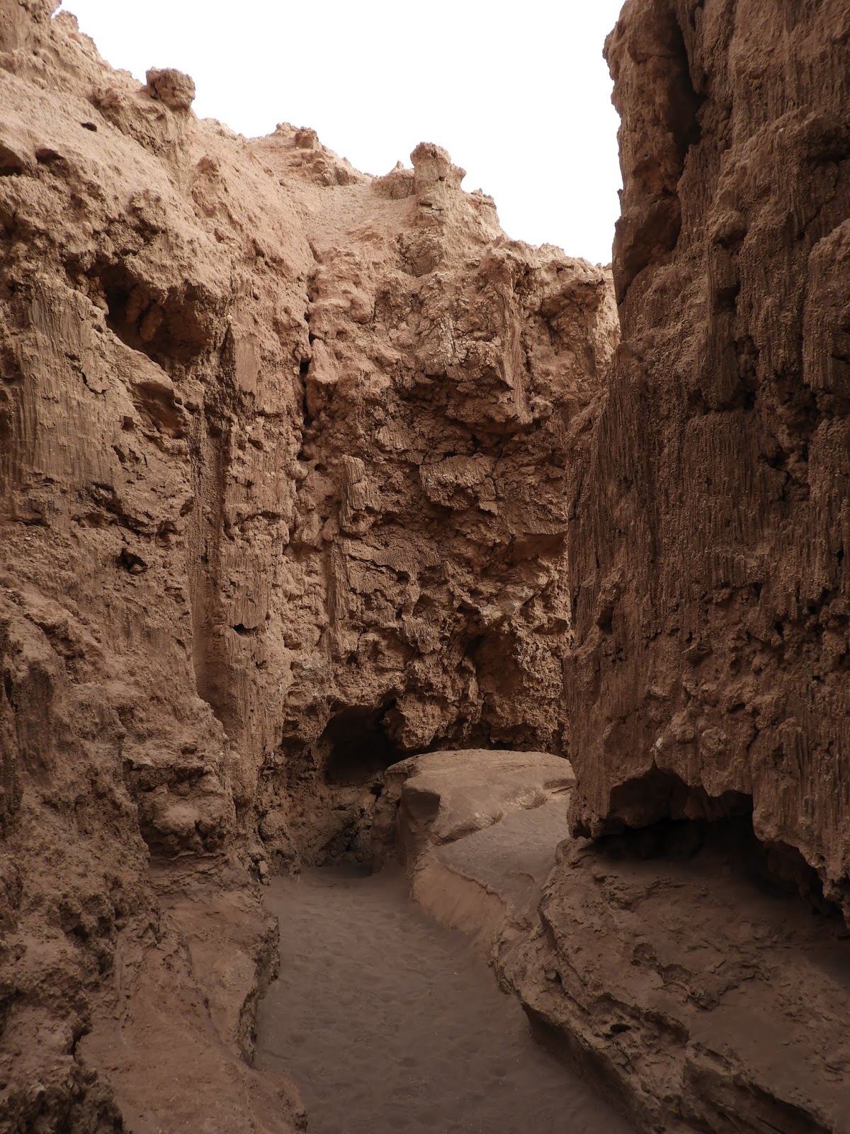
Today, we hiked about 3 ½ miles up a jeep road in the valley just behind Purmamarca, to the end of the road and a bit beyond, up a dry, pink wash.  It is hard to describe the beauty of this place.  The wildly contorted rocks are a giant painter’s palate, with pink, red, green, orange and white masses of color as you walk up the valley.  You can see similar rock formations just walking around the town, but nothing like the steep valley behind the village.  Several softer formations are heavily eroded into pinnacles and spikes and deep mini-gorges that catch the light and shadows.
Selena, the llama
There are a number of hotels in Purmamarca, none that are luxury level.  Ours had a pretty garden with adequate rooms and towels that had seen better days years ago.  Its biggest attraction is Selena, a sweet llama who resides at the hotel and keeps the grass mowed.  After many soft conversations, she finally came over to sniff my hand, which she found less than appealing.  Nevertheless, she kept sniffing and let me pet her ever so carefully for a split second.

I think I will let the photos describe this area because words can’t.  Not that the photos really show you the depth of the colors, but you’ll get the idea.


Purmamarca street and mountains beyond

Sunday, October 28, 2018

Crossing the high altiplano from Chile's Atacama Desert to Purmamarca, Argentina

crossing the altiplano high above the Atacama Desert

Today we drove across the high Andes from San Pedro de Atacama, Chile to Purmamarca, Argentina.  At our high point we were just over 15,800 feet and spent most of the drive between 13,500 and 15,000 feet.  It is a spectacular drive, starting with the climb from the Atacama to the passes in between the huge volcanoes towering over 19,000 feet.  There was little snow on the peaks because Chile is so dry that neither rain nor snow falls, even in the high mountains.
high, barren desert at 15,000 feet on Chilean side
On the Chilean side of the border, the altiplano is mostly barren, though the volcanoes have grass growing to at least 16,000 feet on their western flanks.  Head further east, though, and the volcanic rock changes, leaving the area devoid of vegetation.  As we continued east, across very high valleys, the volcanoes receded and the mountains, still over 16,000 feet, became more contorted from tectonic shifts in the earth.  Here, we began to see salt-rimmed lakes, bushes and grass as well as vicuna and llamas.
lakes and vegetation at high altitude as we drove east
All the llamas are owned by someone, primarily Andean Indian families, and are marked with tassels in their ears or sometimes paint on their hips (which doesn’t wash off because there is no rain).  They are beasts of burden, but also provide meat and hides to their owners.  Outside most of the Andean houses we saw today were piles of llama hides.
We reached the border about 9:15 in the morning and didn’t leave until 10:45.  If you go across the border between Puerto Montt and Bariloche, where there is just a shack with one person staffing it, you can get across in 15 minutes.  There must be something about the remote and very high border crossing we encountered today that requires excessive bureaucracy because it took a ridiculously long time. 
the ever-present llamas
There were 3 Chilean agents who had to approve us and our van leaving the country and more on the Argentine side to welcome us to Argentina.  And, the van and our driver and guide are already returning to Chile so it’s not as if they are going to overstay their visas.  Once all the paperwork was completed, we still had to have the car searched before we could get on our way.  I think this small bevy of officials has too little to do, though there were several dozen trucks
salt flats above Purmamarca
also trying to get across.
Once in Argentina, we crossed a large salt flat where great mounds of salt have been piled up, awaiting transport to a processing plant.  This appears to be a fun family outing as many families were playing on the salt flat, tasting the water in the evaporation ditches and enjoying the cool sunshine at 13,000 feet.
The road down to Purmamarca is long, very steep and very windy, with hairpin curves that almost completely double back on one another.  The uplifted rocks give the mountains a multitude of beautiful colors, which we are about to go out and inspect as we have now arrived in Purmamarca.  Many of the cliffs are conglomerate, so have eroded into giant pinnacles crowded together to make heavily indented cliffs.  Rain is obviously much heavier here than across the mountains because there are large, dry rivers that have clearly carried large amounts of rushing water and deeply eroded gorges of many colors.
the moon above the altiplano


Saturday, October 27, 2018

Lagunas Miscanti and Mineques, Reserva Nacional los Flamencos

Laguna Miscanti

 The Reserva Nacional los Flamencos covers a large area of the Atacama Desert and mountains and is home to 3 of the 4 species of flamingos.  It ranges from the salt flats, with remnants of salty lagoons, to the altiplano valleys at 14,000 feet, along with their 18,000 to 20,000 foot volcanoes surrounding them.
Laguna Mineques
Today we visited Lagunas Miscanti and Mineques, 2 beautiful lakes at 13,600 feet, separated from each other by a low ridge.  These lakes are salty, as you can see from the salty white beaches surrounding them.  It looks like they fill up with the snow runoff in the early spring and then recede in the extremely dry air of the desert.
lemon yellow grass and 19,000 foot peak
On our drive from San Pedro along the huge salt flat south of the town, we saw wild donkeys standing in the sun by the side of the road.  I’m not sure what they were doing right there since there was no vegetation.  I assume they eat the low bushes that grow up a bit higher.
Up on the high altiplano beneath the peaks, we saw, once again, lots of vicuna, blending in beautifully with the bright grass that grows very high.  This grass was more lemon yellow than golden, as we saw farther north around the geyser basin.  It grows up the mountainsides to at least 16,000 feet, providing a glow against the black backdrop of the volcanoes.
vicuna herd high on the altiplano

This is a big tourist mecca, so we were not the only ones enjoying a sparkling day.  Despite dust kicked up by cars and vans, the air is exceptionally clear.  Very few people actually live in the area.  We saw no homes above the village of Socaire, which is about 10,500 feet high and 40 miles from the nearest town to the north.   While you turn off the main paved road onto a dusty, washboarded dirt road to go to the lakes, the main road continues south to a very high pass leading into Argentina.  All day, we were within a few miles of the Argentine border, which we will cross tomorrow on our way to Purmamarca and Salta, Argentina.

San Pedro de Atacama


dogs and tourists, main street of San Pedro de Atacama
San Pedro de Atacama is the major town in this part of the Atacama, the only place where you can fill your car with gas and the only town with a significant tourist infrastructure.  There are dozens of restaurants and nearly 80 hotels, guesthouses and hostels.  Among them are several high-end luxury hotels, but most are geared towards the traveler needing cheaper places to sleep.
San Pedro's adobe church
This is a dusty desert town with unpaved, rutted streets, high adobe walls protecting the pretty homes, hotels and courtyards behind, hiding them from the noise, dust and people on the streets.  It reminds me of Taos years ago, a poorer version, but with the same charm of old adobe houses leaning slightly to one side, narrow alleys with shops and homes, and artisans filling the galleries with their creations.  It is an Andean Indian village that attracts people from all over the Andes countries and Chile to work for a time before moving on.  Many of the locals wear traditional dress, not for the tourists, but because it's what they prefer.
San Pedro homes
The place is filled with tourists.  It’s mostly a backpacker town, but the luxury hotels and the magnificence of the area attract high end tourists as well.  The streets are filled with young people, properly adorned with tattoos and piercings, wild hair atop sunburned faces, probably finding a good dose of drugs as well as alcohol readily available.  Like us, they are here to enjoy the astonishing beauty of the Atacama Desert and the high Andes to the east, towering over the village and the altiplano.
adobe wall protecting a hotel
The main street is a pedestrian street, unpaved, filled with tourists, locals, storekeepers, dogs.  The dogs that are wearing scarves or ribbons or yarn around their necks have owners and are the fortunate ones.  Most of the dogs are on their own and hang out next to the restaurants where they get lots of scraps.  They are in pretty good shape and are very gentle, loving any pet they can get.  Some of the strays clearly have patrons whom they greet with licks and jumps when they appear on the street.  I’m sure they would love to go home with them also.
wall outside hostel
San Pedro plaza

I love the adobe walls with their varied designs and warm colors.  Most are in need of maintenance, but the influx of tourist money is enabling some property owners to repair and upgrade their buildings.  One person who works at our hotel told me it is very expensive to live in San Pedro.  The more tourist demand there is, the more this will be a problem.  And, there just isn’t any place around the town for a workforce to live.


Friday, October 26, 2018

Valle del Arcoiris (Rainbow Valley), Atacama Desert

looking across the high plateau to the volcanoes beyone

San Pedro de Atacama, though small, is one of the larger towns in the heart of the Atacama Desert.  Surrounding it, the desert is enormous, cut up by gorges, some very deep, wide canyons and broad valleys.  The colors of the desert rock are warm, salmon to rose pink to mauve, shot through with white, gray, green and black rocks.  The volcanoes beyond are dark gray to deep purple, with shots of snow on their higher reaches.
colorful rocks in Valle del Arcoiris

Today, we drove northwest out of San Pedro, climbing high up onto the plateau above the town (high point of 11,500 feet) and diving down precipitous grades through steep gorges and wide canyons to the Valle del Arcoiris (Rainbow Valley), to hike and see its multi-colored rock formations.  It is an astonishing place, a series of deep canyons with jagged walls backed by gray-green mountains. 
side valley, Valle del Arcoiris
You can see that the area has been beset by huge upheavals in the earth because the rock plates are contorted and thrust up nearly vertically.  Erosion has carved deep gashes in the softer rock.  Different kinds of rock from different eras blend together with their multiple colors—green, reddish brown, black, white, powder blue, warm gray.  Some of the rock looks like it has been extruded during volcanic eruptions, which obviously were frequent and massive here eons ago.
looking at Valle del Arcoiris from side valley
We hiked up the jeep road to several rugged side canyons, to the point where the road has been blocked off at the entrance to a steep valley.  High up the valley, we stopped to listen.  There was no one else there.  It was absolutely quiet.
llama in Valle del Arcoiris mildly interested in me

Walking back to our car, a well-marked trail led off to a canyon that paralleled the main valley.  It was full of llamas who looked at me with mild interest, but mostly kept munching on the bushes that grow there. 
We decided to continue on to the village of Rio Grande, at the bottom of a very deep gorge with a river running through it.  Though the road from the main highway has been paved very recently, it is still a daunting, but beautiful, drive.  Once you arrive at the edge of the gorge, you descend on a very narrow road, somewhat like the Independence Pass road in Colorado, peering over the cliffs on one side to the river several thousand feet below.  The road is very windy and very steep, so we stayed in second gear and crept down to the bottom, where the road turned into a single track that goes out the other side of the gorge and, ultimately, to a graveled road leading back to San Pedro.  I would not enjoy this road in a winter snowstorm.
gorge above San Pedro de Atacama


Atacama Desert--the highest geyser basin in the world


vicuna blend in with the grass and rocks
Yesterday, we drove north from San Pedro de Atacama to the Del Tatio Geyser Basin, at 14,100 feet, the highest geyser basin in the world.  And still, the Andean volcanoes towered over us.
volcanoes taken from 14,000 foot high valley
Here, there is little vegetation at the lower elevations, but it begins to gather above 10,000 feet with low dusty-green bushes and, still higher, larger bushes and beautiful clumps of golden grass.  In the sunlight, it is a lovely sight, gold and green up against the mauve and gray peaks.  Vicuna and llamas live here--and we saw lots of both.  The vicuna are smaller and blend in so perfectly with the vegetation so that they can be hard to see.  The llamas are many colors from white to spotted to speckled to tan and black or all the above.
llamas in front of Andean house
There are several flamingo lagoons on the way to the geysers, very high at 12,000 to 13,000 feet, and crowded with pink flamingos.  It’s very surprising to see them here when you think of flamingos living at sea level.  A beautiful bird, the Andean Goose, also lives at this elevation.  These birds mate for life and, reportedly, if one dies, the mate stops eating.  We did see mostly pairs, but one lone goose who looked like he was doing fine.
flamingo lagoon
Andean Indian families live in this very high and rugged desert environment.  Their homes are adobe and/or stone.  It looks like their economy is based on raising llamas and vicunas as agriculture is impossible at this high altitude with its very cold nights, even in summer.
small geysers with volcanoes in background
Andean Geese
The geyser basin covers several square miles.  The geysers burble along and then shoot off, mostly several feet, but some reached about 10 feet in height.  There are several mud pots, bull of thick, boiling mud.  Other places, you can hear all the boiling water as you walk along, but there is only noise and a little steam coming out of the holes.  While the geysers are not as spectacular nor as scattered as those at Yellowstone, they keep spouting cheerfully as you walk among them.  And the 18,000 to nearly 20,000 foot volcanoes all around the basin are stunning.  There is a pleasant natural pool fed by the hot springs where you can swim.
colorful fumarole
Most of the excursions to the geyser basin leave at 6 in the morning in order to watch the sun rise over the basin, which is freezing cold at that time, so has lots of steam lighting up the morning.  I do not like to shiver and I prefer to see beautiful places without crowds, so we arrived at about noon and had the place all to ourselves.  It was wonderful.  We had passed about a dozen vans full of people driving back to San Pedro as we drove up the steep, rutted road to the geysers, so we knew we were happily missing the crowds.
The graveled road leads north out of San Pedro and climbs steeply to a high point of about 14,500 feet, then drops slightly to the basin.  The colors of the grass in the sunlight, backed by the dark mountains, are spectacular.  We had lunch on the plateau above the geyser basin, loving the cool air, sunshine and silence in this beautiful world.
our view at our picnic spot

Chile's magnificent Atacama Desert

Valley del Muerte just before sunset, looking across the Atacama at its many volcanoes
After our flight from Easter Island back to Santiago, we stayed at the Holiday Inn at the Santiago airport, so convenient as it is directly across the street from the terminal and we had an early flight yesterday.
We arrived in Calama, the largest city in this part of the Atacama, where we rented a car and drove the 90 km to San Pedro de Atacama, a small, picturesque town in the desert with so much to see and do and dozens of volcanoes overlooking it to the east, many 18,000 to nearly 20,000 feet high.  More about San Pedro in another blog.
large dune at Valle de Luna
Yesterday afternoon, we drove to see some of the beautiful desert valleys.  First, to the Valley of the Moon.  On the way, we passed two young women hitchhiking, so we picked them up and spent the rest of the day with them. 
gorge in the Valle de Luna


They are French and spending over a year hitchhiking through South America.  I asked one of them what she did if she ended up in a car with a scary (as in threatening) driver.  She said she screamed as loud as she could and he would let her out.
The Valley of the Moon is hard to describe, so craggy and weathered and filled with dunes and color and beauty.  We first went to a gorge that required some maneuvering
Valle de Luna dunes
through very tight places, several only about 24 inches high.  I would not want to be there in a flash flood.
Next to a wide valley where gray dunes have piled up against the orange, yellow and purple cliffs.  We climbed one of the dunes for a fantastic view of the valley below, wide, surrounded by cliffs and dunes, rugged.
dunes and cliffs at Valle de Luna
We wanted to end the day at the Valley del Muerte (which should be the Valley del Marte), a deep and extremely jagged valley, where we could watch the sunset.  One guide book said to stay until after the sun had actually set as the glow and the colors were particularly beautiful then.  So, we did.
panorama of sunset at Valle del Muerte
We scrambled up a steep trail to a plateau overlooking the desert below and across to the high peaks, the volcanoes lining the Atacama.  As the sun set, the wind came up, chilling us enough to put on our jackets, but it was too pretty to leave.
I am adding a number of photos to show you how gorgeous this particular desert was on this particular night.  But, I think this is the norm, not a surprise.
sunset view from plateau above Valle del Muerte